Table of Content
▲
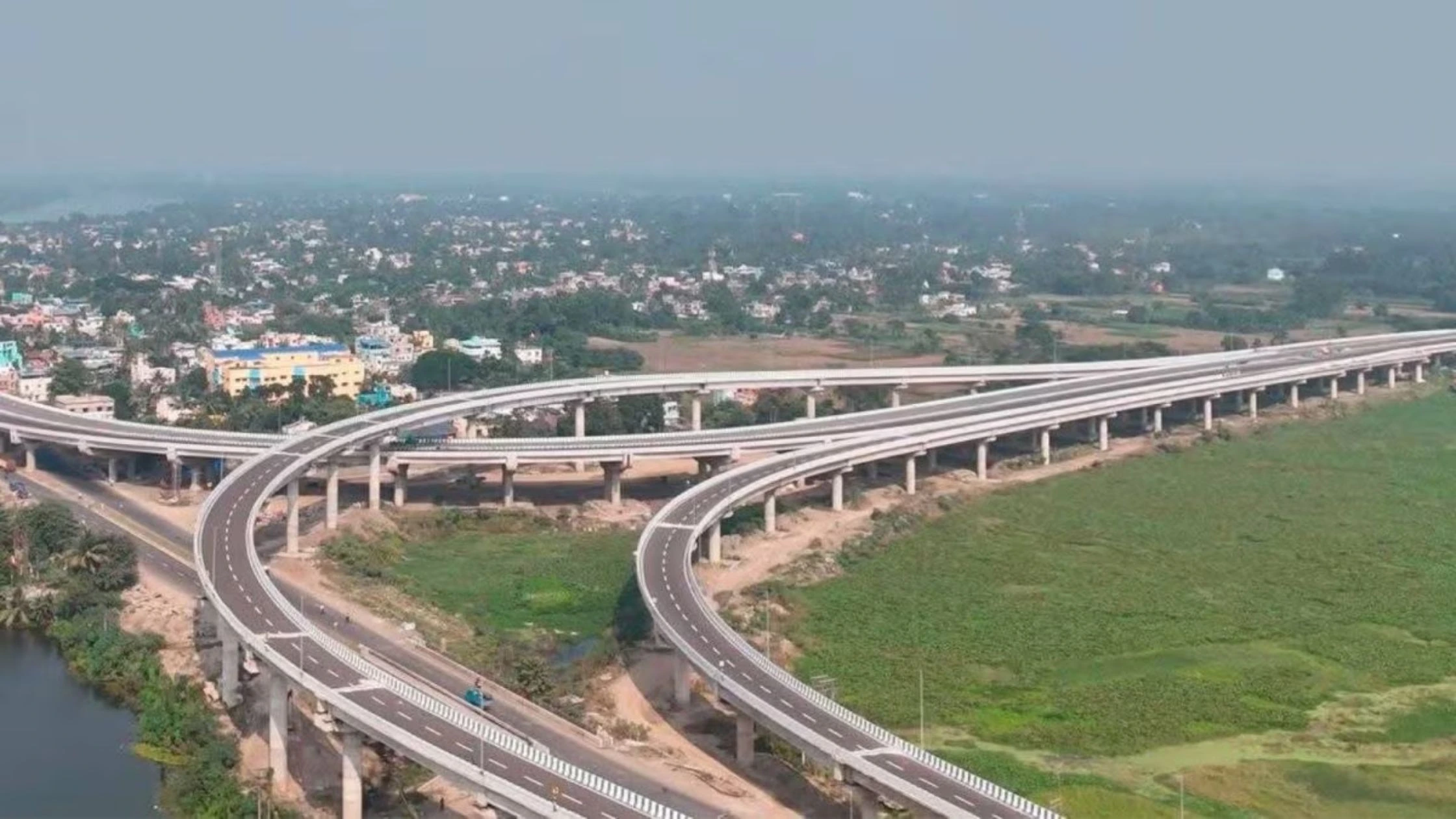
The Kalyani Expressway is a 40-kilometre, 4 to 6-lane signal-free highway connecting Kalyani to Kolkata. Managed by the Kolkata Metropolitan Development Authority (KMDA), it is now the fastest corridor between the two cities, reducing travel time from Kolkata Airport to Kalyani to just 40–45 minutes. Inaugurated on 2nd March 2026, the upgraded expressway also serves as a lifeline for emergency services and a catalyst for regional trade and urban development.
Key Highlights at a Glance
- Length: 40 km
- Lanes: 4 to 6 lanes, signal-free
- Design Speed: Ruling speed 100 km/h; Limiting speed 80 km/h
- Inauguration: 2nd March 2026 by CM Mamata Banerjee
- Project Cost: ₹2,500 Crore (estimated)
- Maintenance Authority: KMDA
- Upgrade Authority: West Bengal Highway Development Corporation Ltd (WBHDCL)
- Major Junctions: Muragacha More, Barrackpore Wireless More, Panpur More, Saheb Colony More, Rajendrapur More, Panchmatha More, Kampa More
- Minor Junctions: 14 locations along the corridor
- Toll Status: Toll road with direct connectivity to Belghoria Highway
- Flyovers: 21 new flyovers covering ~24 km of elevated sections
- Special Features: “Zero Point” elevated link, high-mast LED lighting, pedestrian and light vehicle underpasses
Also Read: Nagpur-Vijayawada Expressway: Facts, Advantages, and Real Estate Opportunities
Overview of Kalyani Expressway
Originally constructed in the 1980s as the Kalyani-Barrackpore Expressway (35 km), the highway was extended by 9 km from Sodepur Road to Barasat in 2005. The KMDA now manages the highway, which runs from Kalyani to Nimta in the 24-Parganas (North) district. This stretch has recently been converted into a 4-lane motorway, while the section from Belgharia to Muragacha has been upgraded to 6 lanes.
The expressway provides a strategic bypass, allowing commuters to avoid congested towns like Sodepur, Barrackpore, and Naihati. It also intersects key feeder roads connecting Barrackpore, Barasat, Madhyamgram, Khardaha, and Kanchrapara, further facilitating seamless regional transit.
Route Map and Major Junctions
Major Junctions
|
Km |
Junction Name |
Type |
|
5+142 |
Muragacha More |
Vehicular Under/Overpass |
|
13+903 |
Barrackpore Wireless More |
Vehicular Under/Overpass |
|
25+363 |
Panpur More |
4-Legged |
|
28+308 |
Saheb Colony More |
4-Legged |
|
29+319 |
Rajendrapur More |
4-Legged |
|
32+224 |
Panchmatha More |
5-Legged |
|
34+385 |
Kampa More |
4-Legged |
Minor Junctions
- 14 locations from 6+167 km to 27+735 km
- Both-side connectivity with pedestrian and light vehicle underpasses
Infrastructure & Design Features
- Carriageways: 2 x 7.0 m each, with 9 m raised median
- Service Roads: 2.5 m to 4.5 m wide divider between main lanes and service lanes
- Shoulders: 2.0 m paved or granular, depending on location
- Drainage: 1.5–2.0 m wide R.C. drains and 600 mm diameter underground H.P. drains along median
- Flyovers & Elevated Sections: 21 flyovers totaling ~24 km
- Special Links: 1.5 km “Zero Point” elevated link connecting Belghoria Expressway directly to Kalyani line
Vehicular & Pedestrian Underpasses
|
Type |
Location Chainage |
Width (m) |
Span Arrangement |
|
Vehicular |
5+140, 13+895, 25+359, 28+303, 30+379 |
10.5 x 2 |
1x50/24/16 |
|
Light Vehicular |
6+725, 9+136, 12+141, 14+875, 20+066, 29+313, 32+212 |
10.5 x 2 |
12–24 m |
|
Pedestrian |
10+213, 10+900, 18+205, 21+140, 26+850 |
10.5 x 2 |
RCC Box |
Connectivity with the Belghoria Expressway
The Belghoria Expressway, a 16 km, 4-lane toll corridor in Kolkata’s northern suburbs, connects NH-16 and NH-19 at Rajchandrapur to Dakshineswar and NH-12 near Kolkata Airport. A proposed 6-lane bridge linking Belghoria Expressway and Kalyani Expressway is expected to enhance northern commuting and reduce congestion on Jessore Road and BT Road.
Nearby employment hubs include Sector V, Salt Lake City (14 km), and New Town (20 km), which house IT and corporate firms like Tech Mahindra, TCS, and Capgemini.
Benefits of Kalyani Expressway
- Reduced Travel Time: Airport to Kalyani under 45 minutes.
- Urban & Economic Development: Facilitates trade, commercial growth, and real estate development along NH-34 and feeder routes.
- Traffic Decongestion: Avoids bottlenecks in Barrackpore, Sodepur, Naihati, and Jessore Road.
- Safety Enhancements: High-mast LED lighting, pedestrian underpasses, and service roads.
- Emergency Services: Acts as a Green Corridor for AIIMS Kalyani, enabling fast medical transport.
- Connectivity: Seamless links to NH-12, Belghoria Expressway, and key state highways.
- Modern Infrastructure: 21 flyovers, 24 km elevated sections, and a 1.5 km Zero Point elevated link.
Also Read: Agra Gwalior Expressway: Route, Construction Updates, Travel & Real Estate Impact
Economic & Social Implications
- Boosts regional trade along the Hooghly River corridor.
- Supports suburban development in Kalyani, Barasat, and surrounding towns.
- Improves access to Kolkata’s northern suburbs for residents, students, and professionals.
- Increases property values along the corridor due to reduced travel time and enhanced infrastructure.
Conclusion
The Kalyani Expressway is a strategic infrastructure project that has transformed commuting between Kalyani and Kolkata. With its signal-free, high-speed design, multiple flyovers, underpasses, and enhanced connectivity, it reduces travel time, decongests existing routes, supports regional trade, and enables efficient emergency services. This 4–6 lane corridor is a vital lifeline for commuters, businesses, and healthcare access in northern West Bengal.

Ans 1. The Kalyani Expressway is a 40 km, 4–6 lane signal-free highway connecting Kalyani to Kolkata. It was inaugurated on 2nd March 2026.
Ans 2. The upgraded expressway reduces travel time to approximately 40–45 minutes.
Ans 3. The Kolkata Metropolitan Development Authority (KMDA) manages the expressway, and the West Bengal Highway Development Corporation Ltd (WBHDCL) handled the upgrade.
Ans 4. Key features include 21 flyovers covering ~24 km, a 1.5 km “Zero Point” elevated link, high-mast LED lighting, pedestrian and light vehicle underpasses, and signal-free traffic design.
Ans 5. Major junctions include Muragacha More, Barrackpore Wireless More, Panpur More, Saheb Colony More, Rajendrapur More, Panchmatha More, and Kampa More.
Ans 6. Yes, it connects directly to the Belghoria Expressway and provides seamless links to NH-12 and other state highways.
Ans 7. Benefits include reduced travel time, traffic decongestion, safer travel with underpasses and lighting, and fast access for emergency services.
Ans 8. It supports trade, urban growth, real estate development, improved access to employment hubs like Salt Lake City and New Town, and increases property values along the corridor.
Ans 9. Yes, it is a toll road, with integrated connectivity to the Belghoria Expressway.
Ans 10. The ruling speed is 100 km/h, and the limiting speed is 80 km/h, ensuring fast and smooth traffic flow.