Table of Content
▲- What Is the Amas Darbhanga Expressway?
- Why Is the Amas Darbhanga Expressway Important for Bihar?
- Amas Darbhanga Expressway: Quick Facts
- Which Areas Will the Amas Darbhanga Expressway Connect?
- What Is the Route of the Amas Darbhanga Expressway?
- Which Villages Will the Expressway Pass Through?
- Who Is Building the Amas Darbhanga Expressway?
- How Will the Expressway Improve Airport Connectivity?
- What Is the Real Estate Impact of Amas Darbhanga Expressway?
- How Will Farmers and Local Businesses Benefit?
- Latest Update on Amas Darbhanga Expressway (2025–26)
- What Are the Major Benefits of NH 119D?
- Conclusion
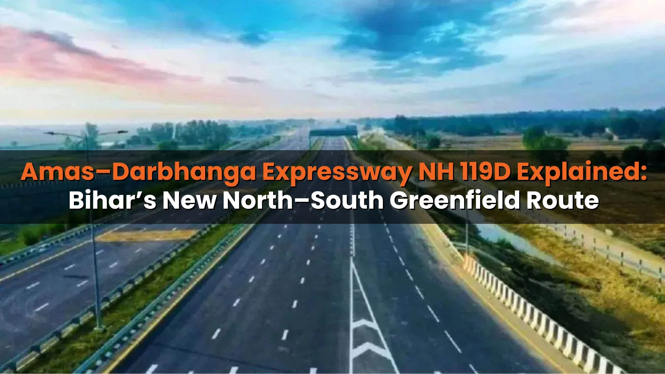
The Amas Darbhanga Expressway is a 189-km, six-lane, access-controlled greenfield highway that will transform connectivity between South and North Bihar. Approved under the Bharatmala Pariyojana and developed by NHAI, the expressway (NH 119D) is designed to cut travel time to nearly 4 hours, boost trade, improve logistics, and unlock large-scale economic and real estate growth across central Bihar.
What Is the Amas Darbhanga Expressway?
The Amas Darbhanga Expressway, also known as NH-119D or the Gaya–Darbhanga Expressway, is Bihar’s first major north–south access-controlled greenfield expressway.
Key Purpose of the Project
- Seamless connectivity between Amas (Gaya) and Darbhanga
- Faster movement of people and goods across Bihar
- Strengthening Bihar’s road infrastructure backbone
- Supporting agriculture, logistics, tourism, and real estate growth
Once operational, it will become Bihar’s primary economic corridor running through the state’s heart.
Also Read: 7 Most Posh Areas in Darbhanga for a Premium Living Experience
Why Is the Amas Darbhanga Expressway Important for Bihar?
Bihar has historically lacked high-speed, access-controlled highways. The Amas Darbhanga Expressway changes that by:
- Linking NH-19 (Delhi–Kolkata corridor) to NH-27
- Integrating with Patna Outer Ring Road
- Connecting key urban, agricultural, and industrial zones
- Reducing dependency on congested city roads
This expressway positions Bihar closer to infrastructure standards seen in states like Uttar Pradesh and Maharashtra.
Amas Darbhanga Expressway: Quick Facts
|
Particular |
Details |
|
Also Known As |
NH-119D, Gaya–Darbhanga Expressway |
|
Total Length |
~189 km |
|
Estimated Cost |
₹5,000 crore (approx.) |
|
Lanes |
6 (Access Controlled) |
|
Right of Way (RoW) |
60 metres |
|
South Terminal |
Amas, Gaya district |
|
North Terminal |
Bela Nawada, Darbhanga district |
|
Project Owner |
NHAI |
|
Model |
Hybrid Annuity Model (HAM) |
|
DPR Consultant |
SA Infrastructure Consultants Pvt. Ltd. |
|
Target Completion |
March 2026 |
Which Areas Will the Amas Darbhanga Expressway Connect?
Districts Covered by NH 119D
The expressway passes through seven districts:
- Aurangabad / Gaya (Amas)
- Arwal
- Jehanabad
- Nalanda
- Patna
- Vaishali
- Samastipur
- Darbhanga
This alignment ensures balanced development across urban and rural Bihar.
What Is the Route of the Amas Darbhanga Expressway?
Route Overview
- Start Point: Amas village (Gaya district) on NH-19
- End Point: Bela Nawada village (Darbhanga district) on NH-27
The route strategically uses:
- Sections of Patna Outer Ring Road
- Kachchi Dargah–Bidupur Ganga Bridge (9.75 km)
This allows traffic to bypass Patna’s congested inner roads completely.
Which Villages Will the Expressway Pass Through?
Amas Darbhanga Expressway Village List
- Amas
- Mathurapur
- Guraru
- Panchanpur
- Bela
- Ibrahimpur
- Okri
- Pabhera
- Ramnagar
- Sabalpur
- Chaksikandar
- Dabhaich
- Bahuara
- Shahpur Baghauni (Tajpur)
- Shiv Nandanpur (Burhi Gandak)
- Basudevpur
- Ramnagar (Laheriasarai)
- Bela
- Nawada (Darbhanga)
These villages are expected to see sharp growth in land values and infrastructure.
Who Is Building the Amas Darbhanga Expressway?
Packages & Contractors
|
Package |
Stretch |
Length |
Contractor |
|
Package 1 |
Amas–Shivrampur |
55 km |
Megha Engineering (MEIL) |
|
Package 2 |
Shivrampur–Ramnagar |
54 km |
Megha Engineering (MEIL) |
|
Package 3 |
Kalyanpur–Balbhadrapur |
47 km |
Megha Engineering (MEIL) |
|
Package 4 |
Balbhadrapur–Bela Nawada |
47 km |
Ram Kripal Singh Construction Pvt. Ltd. |
Construction is being monitored directly by NHAI under Bharatmala.
How Will the Expressway Improve Airport Connectivity?
Airport Access Benefits
Darbhanga Airport
- Faster, signal-free access
- Supports rising air traffic demand in North Bihar
Patna Airport
- Direct connectivity via Patna Outer Ring Road
- Avoids city congestion completely
Gaya International Airport
- Better access for Buddhist tourism and international travelers
This tri-airport connectivity significantly boosts tourism and logistics efficiency.
What Is the Real Estate Impact of Amas Darbhanga Expressway?
Expected Real Estate Changes
- Land price appreciation near interchanges
- Rise in residential plots, townships, and affordable housing
- Increased warehouse and logistics parks
- Growth of commercial hubs and service clusters
High-Potential Zones
- Arwal & Jehanabad (emerging markets)
- Vaishali & Samastipur (logistics-driven demand)
- Peripheral Patna regions (spillover development)
Similar expressways in UP (Purvanchal Expressway, Bundelkhand) have seen 30–60% land value appreciation within 3–5 years.
How Will Farmers and Local Businesses Benefit?
- Faster transport of crops to mandis and urban markets
- Reduced logistics cost and spoilage
- Improved access to cold storage and processing units
- Better income realization for farmers
This aligns directly with Bihar’s agriculture-driven economy.
Also Read: Gorakhpur Shamli Expressway Map, Route, Facts, Cost, Timeline & Real Estate Impact Explained
Latest Update on Amas Darbhanga Expressway (2025–26)
Construction Status (as of December 30, 2025)
- Darbhanga-end structural work nearing completion
- Pillar construction near Kakarghati railway crossing is almost complete
- Expressway crossing over the Darbhanga–Sakari railway line in the final phase
- Work accelerated across all packages after land-clearance resolution
- Project remains on track for March 2026 completion
Additionally, a CAT-II Instrument Landing System is being installed at Darbhanga Airport near the expressway alignment, enhancing low-visibility flight operations.
What Are the Major Benefits of NH 119D?
Key Advantages
- Reduced travel time between North & South Bihar
- Massive infrastructure boost for rural regions
- Logistics and trade growth
- Real estate appreciation
- Tourism expansion (Gaya, Darbhanga, Patna)
- Farmer income improvement
Conclusion
The Amas Darbhanga Expressway is more than a highway it is Bihar’s economic lifeline in the making. By connecting remote regions with major urban and trade hubs, NH 119D will unlock growth in agriculture, real estate, tourism, and logistics. Once operational, it will redefine how Bihar moves, trades, and grows placing the state firmly on India’s high-speed infrastructure map.


Ans 1. It is a 189-km, six-lane, access-controlled greenfield highway connecting Amas (Gaya) to Darbhanga, designed to reduce travel time, improve trade, boost logistics, and stimulate economic and real estate growth in Bihar.
Ans 2. The expressway passes through Aurangabad, Arwal, Jehanabad, Nalanda, Patna, Vaishali, Samastipur, and Darbhanga districts. Key villages along the route include Amas, Mathurapur, Panchanpur, Ramnagar, Basudevpur, and Bela Nawada, among others.
Ans 3. NHAI is overseeing the project under Bharatmala Pariyojana. Contractors include Megha Engineering (MEIL) for Packages 1–3 and Ram Kripal Singh Construction Pvt. Ltd. for Package 4. Construction follows the Hybrid Annuity Model (HAM).
Ans 4. The expressway is expected to drive land value appreciation, increase residential and commercial projects, support logistics hubs, and stimulate townships in areas like Arwal, Jehanabad, Vaishali, and peripheral Patna. Similar corridors in UP have seen 30–60% land value growth.
Ans 5. It provides faster, signal-free access to Darbhanga, Patna, and Gaya airports. The expressway integrates with the Patna Outer Ring Road, reduces congestion, and supports tourism and logistics efficiency across the region.
Ans 6. The project is on track for completion by March 2026, with structural work, pillar construction, and railway crossings nearing final stages as of December 2025.
Ans 7. Key advantages include reduced travel time, enhanced rural and urban connectivity, logistics and trade growth, real estate appreciation, tourism development, and better income for farmers through improved crop transport.