Table of Content
▲
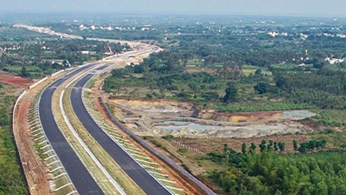
The Bangalore Chennai Expressway is changing connectivity between two of South India's major cities. Bengaluru has long been connected to Chennai via highways, but this world-class greenfield project, conceived under the Bharatmala Pariyojana program, is going to transform travel, reducing journey times, enhancing trade and regional economic development. In this blog we discuss the expressway route, expressway map, toll rates and other important details of the project.
Overview
The Chennai Bangalore Expressway is a significant infrastructure project aimed at connecting Chennai to Bangalore through a state-of-the-art 258 km four-lane corridor that is being executed by the National Highways Authority of India (NHAI). It spans the states of Andhra Pradesh, Tamil Nadu, and Karnataka, thus being one of the most monumental expressway schemes not only in India but also in the region.
The project started in the 1990s and gained renewed momentum in 2018. In January 2021 it was formally designated National Expressway 7 (NE-7). The expressway is expected to cost ₹ 18,000 crore and will reduce travel time to about 2.15 hours (from 5 – 6 hours), which will undoubtedly save precious time for commuters and freight.
Also Read: Adani Group Set for Acquisition: In Advanced Talks with Emaar India
Key Project Details
Below is a summary of the expressway’s essential facts:
|
Parameter |
Details |
|
Project Cost |
INR 18,000 Crore |
|
Length |
258 km |
|
Starting Point |
Hoskote, Karnataka |
|
Endpoint |
Sriperumbudur, Tamil Nadu |
|
Alternate Name |
National Expressway 7 (NE-7) |
|
Number of Lanes |
Initially 4 (expandable to 8) |
|
Land Acquisition |
2560 hectares |
|
Developer |
National Highways Authority of India (NHAI) |
|
States Covered |
Karnataka, Andhra Pradesh, Tamil Nadu |
|
Completion Date |
Expected by August 2025 |
|
Speed Limit |
120 km/hr |
This comprehensive table provides a quick reference to the Bangalore Chennai expressway project, outlining its scale, cost, and strategic importance.
Route and Connectivity
The expressway offers the shortest route between Chennai and Bangalore, bypassing longer, congested alternatives. Key cities along the Bangalore Chennai expressway include:
- Hoskote (Karnataka)
- Malur (Karnataka)
- Bangarapet (Karnataka)
- Kolar Gold Fields (Karnataka)
- Venkatagirikota and Palamaner (Andhra Pradesh)
- Gudiyatham and Arakkonam (Tamil Nadu)
- Sriperumbudur (Tamil Nadu)
This strategically planned route not only cuts the distance by approximately 80 km compared to traditional routes like the Golden Quadrilateral but also ensures smoother traffic flow with modern road infrastructure and advanced safety features.
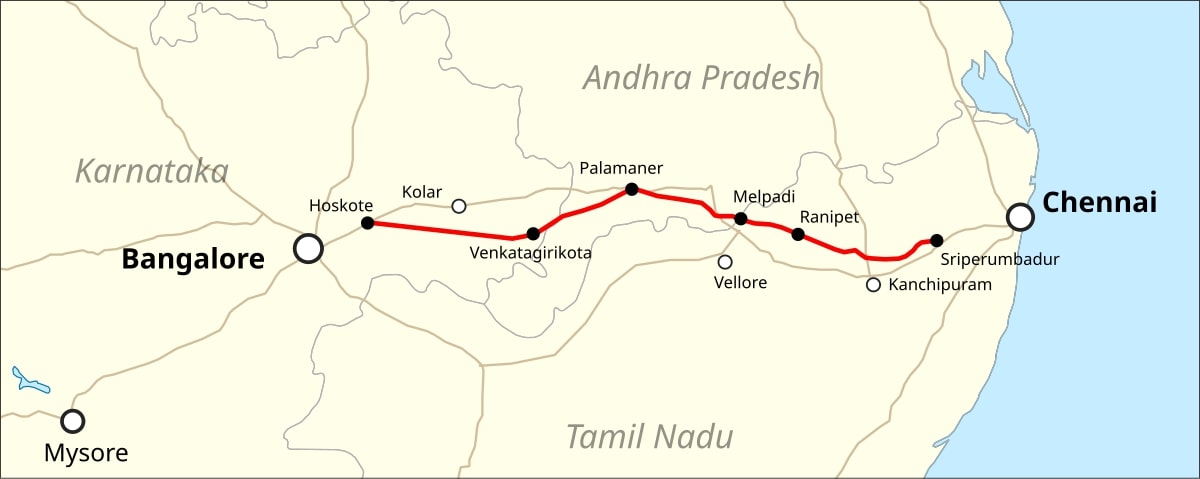
Map and Spur Routes
The expressway from Bangalore to Chennai has several spur routes that provide additional connectivity to surrounding areas. Spur routes are intended to provide access between the major main corridor and the major regional roadways and municipalities to enhance traffic control and reduce congestion on the primary route. The map of the expressway illustrates its position connecting three states, with potential spurs outlined to enhance regional purposes.
Also Read: Govt to Return Unused Highway Land to Owners, Speeding Up Acquisitions & Reducing Disputes
Toll Rates
The toll rates of the Bangalore Chennai expressway are aimed to be competitive and facilitate smooth revenue generation for upkeep purposes. While the final tolls may differ, it is assumed that tentative rates are:
|
Vehicle Type |
Charge per km (in Rs) |
|
Light Motor Vehicles |
0.65 |
|
Mini Bus / Large Goods |
1.05 |
|
Trucks and Buses |
2.20 |
|
Three-Axle Trucks |
2.40 |
|
Multi-Axle Trucks |
3.45 |
|
Oversized Trucks |
4.20 |
These rates have been set to balance affordability for regular commuters while ensuring that the maintenance of the Bangalore Chennai expressway remains sustainable.
Project Phases and Timeline
The development of the expressway is divided into several phases to facilitate the completion and construction process. Below is an overview of the timeline for the project:
- 1990s: Initial announcement during the Union Budget by P. Chidambaram.
- August 2018: Commencement of land acquisition.
- February 2019: Achieved 60% land acquisition.
- August 2019: Construction work officially started.
- November 2020: Land acquisition completed for 2560 hectares and tenders invited.
- September 2021: Major contractor agreements finalized.
- December 2024: First 71 km stretch in Karnataka operational.
- August 2025: Expected full operational launch of the expressway.
By adopting this phased approach, we guarantee that each portion of the Bangalore Chennai expressway will be executed accurately and to the highest standards of quality.
Impact on Economy and Real Estate
The expressway is set to create a ripple effect across the region. Some of the anticipated benefits include:
- Reduced Travel Time: Cutting travel time dramatically, which will boost productivity and ease logistic challenges.
- Economic Growth: Improved connectivity is expected to spur industrial development and boost regional trade.
- Real Estate Boom: With enhanced accessibility, property values in areas adjacent to the expressway, such as Sriperumbudur and Hoskote, are likely to appreciate significantly.
- Employment Opportunities: The project will generate numerous direct and indirect jobs, fostering economic development in the areas it traverses.
The Bangalore Chennai expressway promises to be a vital catalyst for economic transformation in South India by connecting key economic hubs and industrial corridors.
Conclusion
The Chennai Bangalore Expressway is not just a road-it is a lifeline which promises to transform connectivity between Chennai and Bangalore. With its modern and cutting-edge infrastructure, reduced journey times, and a holistic development framework, the expressway will have some significant implications social and economic aspects to trade, tourism and regional development.
As the development progresses towards a projected completion in August 2025, a variety of stakeholders including commuters, investors, and local communities are all excited about the benefits the expressway promises to bring. Combining modern technology and sustainable development frameworks with strategic planning, the Bangalore Chennai Expressway is to be landmark feat in the planning of transport infrastructure in India.
Also Read: Shaktipeeth Expressway: Nagpur-Goa Route, Timeline & Essential Facts


Ans 1. It's a 258 km, four-lane greenfield expressway connecting Chennai and Bangalore, designed under the Bharatmala Pariyojana to improve regional connectivity.
Ans 2. The project is expected to be fully operational by August 2025, with a phased launch including early segments already in progress.
Ans 3. Toll charges vary by vehicle type—light motor vehicles are charged around ₹0.65 per km, while trucks, buses, and oversized vehicles have higher rates up to ₹4.20 per km.
Ans 4. Enhanced connectivity is expected to boost property values along the corridor, stimulate regional trade, and foster industrial and urban development in adjacent areas.
Ans 5. The expressway is being developed by the National Highways Authority of India (NHAI) as part of the Bharatmala Pariyojana program.
Ans 6. Key milestones include initiation of land acquisition in 2018, contractor agreements finalized by September 2021, a partial stretch operational by December 2024, and full launch expected by August 2025.
Ans 7. The expressway connects with other major corridors and includes spur routes that enhance regional connectivity, linking key urban areas and facilitating smoother inter-city travel.
Ans 8. The new expressway is expected to cut the travel time drastically from 5–6 hours down to about 2.15 hours, significantly boosting efficiency for commuters and freight transport.