
Table of Content
▲
The National Informatics Centre (NIC) has introduced the Unique Land Parcel Identification Number (ULPIN), also known as Bhu-Aadhaar. ULPIN allows individuals to verify the existence of land and obtain accurate information about it. Here, we will share more details about ULPIN, how to check your land records using it, and its advantages.
What is ULPIN?
ULPIN, or Bhu-Aadhaar, is a 14-digit alphanumeric code assigned to every land parcel in India to create a standardized identification system. This initiative enhances transparency and simplifies the monitoring of land records across the country. Developed under the Digital India Land Records Modernization Programme (DILRMP) and launched in 2021, ULPIN uses geo-referenced cadastral maps to identify land parcels and provide precise information about them. Bhu-Aadhaar helps efficiently manage and resolve disputes related to land parcels.
What is ULPIN made of?
ULPIN, or Bhu-Aadhaar, is an alphanumeric code that references specific land parcels. It comprises:
- State code: Indicates the state where the land is located.
- District code: Specifies the district of the land's location.
- Taluka code: Denotes the taluka where the land is situated.
- Village code: Identifies the village where the land is found.
- Survey number: A unique ID assigned to the land parcel.
This comprehensive coding system helps streamline land record management and ensures accuracy and transparency.
How can you use ULPIN to check land records?
- Log on to the state land records website.
- Check out for the section, search property using ULPIN.
- Enter ULPIN number and access the required information.
- The information provided will include owner’s name, location, land details, etc.
Benefits of ULPIN
- Transparency: ULPIN serves as the single authoritative source for all land-related information, ensuring authenticity and promoting transparency.
- Single Window: ULPIN offers a centralized platform for all land-related services, benefiting those interested in buying or selling property.
- Minimizes Disputes: With accurate information readily available, land-related disputes are significantly reduced.
Also Read: What is E-Stamp and All You Need to Understand About It
ULPIN status in India
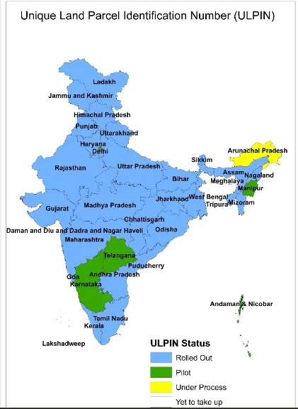
ULPIN has been implemented in 29 states and union territories.
- Daman and Diu
- Gujarat
- Nagaland
- Rajasthan
- Tripura
- Uttar Pradesh
- Ladakh
- Goa
- Maharashtra
- Assam
- Jharkhand
- Haryana
- Punjab
- Dadra and Nagar Haveli
- Tamil Nadu
- West Bengal
- Chandigarh
- Madhya Pradesh
- Karnataka
- Himachal Pradesh
- Sikkim
- Kerala
- Chhattisgarh
- Odisha
- NCT of Delhi
- Uttarakhand
- Bihar
- Jammu and Kashmir
- Mizoram
Pilot testing of ULPIN has been done in four states/ UTs.
- Puducherry
- Manipur
- Telangana
- Andaman and Nicobar Island.
Some states/UTs like Madhya Pradesh, Ladakh and Jammu & Kashmir are also using ULPIN in SVAMITVA.
Aquire Acres.com POV
Bhu-Aadhaar is a crucial tool designed to enhance the transparency and efficiency of land-record keeping in India. It offers convenient access to accurate land data anytime, anywhere, making it a valuable resource for users.
Also Read: Everything You Should Know About the Smart Cities Mission

_1784528630.webp)
_1784272311.webp)


Ans 1. The Unique Land Parcel Identification Number (ULPIN) is a component of the Digital India Land Records Modernization Programme (DILRMP). ULPIN is assigned to land parcels based on their longitude and latitude coordinates, utilizing precise surveys and geo-referenced cadastral maps.
Ans 2. The ULPIN will remain the same if a property is merely transferred to another person. Moreover, the existing documents have already been tested and issued with ULPINs. Citizens can view these records on the official website (https://bhulekh.mahabhumi.gov.in). The ULPIN will be generated for all new 7/12 documents.
Ans 3. ULPIN is a 14-digit Alpha–Numeric Unique ID for each land parcel. This is the next step in the Digital India Land Records Modernisation Programme (DILRMP), which began in 2008.
Ans 4. The idea of a unique identification number has been effectively used to allow for the speedy retrieval of information along with easy land identification at KSLB. Each and every plot of Government land has received a 12-digit code according to the following format: KRD 01 01 01 001.
Ans 5. Plot number or survey number is an identity number which is given to a piece of land by the government or local municipal authorities.
Ans 6. Unique Land Parcel Identification Number System It is a 14-digit identification number accorded to a land parcel. ULPIN is a Single, Authoritative Source of Truth for information on any parcel of land or property to provide Integrated Land Services to the citizens as well as all stakeholders.