_1753700223.webp)
Table of Content
▲- Quick Overview of Chennai Peripheral Ring Road
- Chennai Peripheral Ring Road: Detailed Route Map
- Towns, Highways, and Nodes Linked by CPRR
- Salient Features of the CPRR Project
- Advantages of the Chennai Peripheral Ring Road
- Real Estate Potential Around the Chennai Peripheral Ring Road
- Section-wise Construction Status (As of 2025)
- Land Acquisition and Community Impact
- Phase-Wise Progress Report
- Final Thoughts:
If you've ever driven through Chennai during peak hours, you know the struggle of navigating its congested arterial roads. I’ve faced those long queues too, wondering when better infrastructure would arrive. Fortunately, that change is already underway with the Chennai Peripheral Ring Road.
The Chennai Peripheral Ring Road (CPRR) is a landmark infrastructure initiative that is poised to redefine the transportation landscape of Tamil Nadu’s capital. Spanning 132.87 kilometers, this ambitious expressway is not only a solution to traffic congestion but also a growth catalyst for logistics, real estate, and industrial expansion. Designed as a six-lane, access-controlled highway with two service lanes on each side, the CPRR links Ennore Port in the north to Mamallapuram in the south, creating a seamless loop around the city.
Let’s take a detailed look into the scope, significance, and current status of this transformative project.
Quick Overview of Chennai Peripheral Ring Road
- Total Length: 132.87 km
- Estimated Project Cost: ₹12,301 crore
- Highway Type: Access-controlled, 6-lane expressway + 2 service lanes
- Design Speed: 120 kmph
- Completion Deadline: January 2026
- Implementing Body: Tamil Nadu Road Development Company (TNRDC)
- Project Model: Engineering, Procurement and Construction (EPC)
Funding Agencies:
- JICA (Japan International Cooperation Agency): ¥40,074 million (for Section 1)
- AIIB (Asian Infrastructure Investment Bank): USD 378 million (Sections 2 & 3)
- OPEC Fund for International Development (OFID): USD 100 million
Also Read: Top 10 Longest Expressways in India in 2025 – Connecting India’s Future
Chennai Peripheral Ring Road: Detailed Route Map
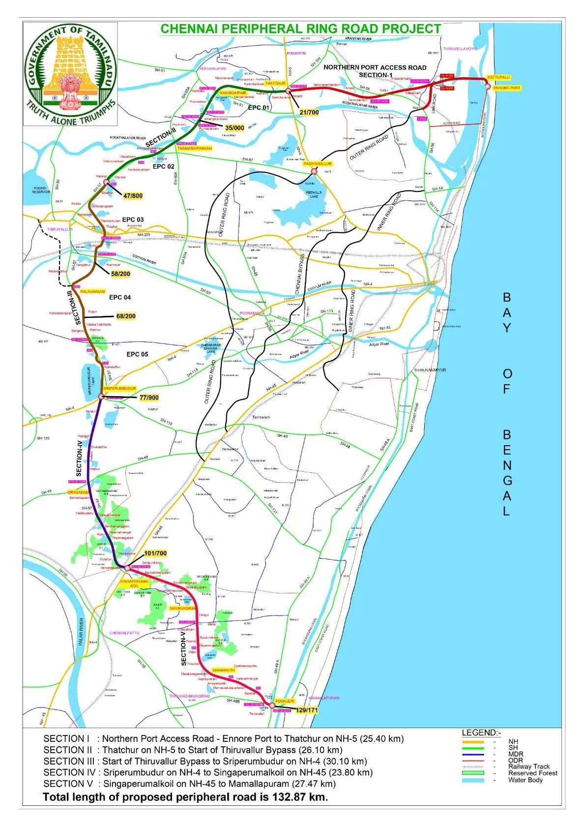
The CPRR is conceived as Chennai’s fourth ring road, a greenfield corridor encircling the metropolitan area. It connects five vital segments:
- Ennore Port to Thatchur (NH-16)
- Thatchur to Thiruvallur Bypass (NH-716)
- Thiruvallur Bypass to Sriperumbudur (NH-48)
- Sriperumbudur to Singaperumalkoil (NH-32)
- Singaperumalkoil to Poonjeri Junction near Mamallapuram (ECR)
These segments connect Chennai’s northern industrial zones to the southern coastal belt, ensuring rapid movement for commercial and passenger vehicles.
Towns, Highways, and Nodes Linked by CPRR
The Chennai Peripheral Ring Road connects key towns and junctions, including:
- Towns: Singaperumalkoil, Sriperumbudur, Tiruvallur, Tamaraipakkam, Periyapalayam, Puduvoyal, Kattupalli
- Highways Intersected: NH5 (Chennai–Tada), NH4 (Chennai–Bengaluru), NH45 (Chennai–Trichy), NH716, and ECR
This design ensures seamless access between ports, industries, and residential suburbs, reducing dependency on Chennai’s core road network.
Salient Features of the CPRR Project
- First Access-Controlled Expressway in Tamil Nadu
Uninterrupted flow with defined entry and exit points helps reduce accidents and enhances travel efficiency. - High-Capacity Multi-Lane Design
Six main lanes with shoulders plus two service lanes on each side for local movement. - Enhanced Port Connectivity
Strategic links to Ennore and Kattupalli Ports support faster and more efficient cargo movement. - Smart Road Features
Includes Intelligent Transport Systems (ITS) such as electronic tolling, traffic monitoring, and emergency services. - Integration with National Projects
Cross-links with NHAI projects like the Bangalore–Chennai Expressway and Chittoor–Thatchur Expressway, amplifying inter-state logistics efficiency.
Also Read: Gorakhpur Link Expressway: Enhancing Connectivity and Growth in Eastern Uttar Pradesh
Advantages of the Chennai Peripheral Ring Road
- Traffic Decongestion
Long-haul freight and intercity traffic can bypass central Chennai, relieving inner-city road pressure. - Faster Transit Times
Improved road geometry and access control enable consistent high-speed travel, saving time and fuel. - Economic and Industrial Boost
Areas like Sriperumbudur and Oragadam benefit from smoother connectivity, attracting investment and job creation. - Safer Commutes
Smart design and monitoring reduce accidents and increase commuter confidence. - Environmental Sustainability
Fewer traffic jams mean lower emissions, supporting Chennai’s goals for greener growth.
Real Estate Potential Around the Chennai Peripheral Ring Road
The CPRR’s influence on real estate is already visible. Connectivity improvements have triggered land value appreciation and new project launches in:
- Poonamallee
- Sriperumbudur
- Vandalur
- Navalur
Developers are focusing on integrated townships, logistics hubs, and industrial corridors along the CPRR, redefining Chennai’s suburban expansion.
Section-wise Construction Status (As of 2025)
|
Section |
Route |
Length (km) |
Status |
|
I |
Ennore Port to Thatchur |
25.4 |
80% complete; facing delays due to utilities |
|
II |
Thatchur to Thiruvallur Bypass |
26.1 |
Under active construction |
|
III |
Thiruvallur Bypass to Sriperumbudur |
30.1 |
79% completed by L&T |
|
IV |
Sriperumbudur to Singaperumalkoil |
23.8 |
Nearing completion; service lanes ongoing |
|
V |
Singaperumalkoil to Poonjeri Junction |
27.47 |
Land acquisition in progress; revised to six lanes |
Land Acquisition and Community Impact
Total land acquired: 234.32 hectares
- Private Wet Land: 53.99 ha
- Private Dry Land: 101.83 ha
- Government Land: 78.5 ha
More than 30 villages have been impacted, including Kattupalli, Minjur, Thiruvottiyur, Vandalur, and Kovalam. Around 676 families are being displaced, prompting detailed resettlement strategies.
Challenges Encountered:
- Patta record disputes
- Insufficient compensation concerns
- Legal disputes are delaying fund releases
Phase-Wise Progress Report
- Phase 1 (Ennore to Thatchur): 80% work complete despite terrain challenges
- Phase 2 (Thatchur to Pattabiram): Land acquisition underway
- Phase 3 (Tiruvallur to Sriperumbudur): Fast-paced work by L&T, launched in May 2025
- Phase 4 (Sriperumbudur to Singaperumal Koil): Service road development nearing finish
- Phase 5 (Singaperumal Koil to Mamallapuram): Land work almost done; awaiting tenders
Also Read: Delhi Mumbai Expressway Map, Route & Real Estate Impact
Final Thoughts:
The Chennai Peripheral Ring Road represents a new era of infrastructure-led development. More than just a highway, it is a powerful enabler of mobility, economic upliftment, environmental sustainability, and urban decongestion. As we approach the 2026 deadline, Chennai is inching closer to realizing a robust, connected future.
Whether you are a commuter, investor, policymaker, or real estate developer, CPRR is a project that demands your attention.
Follow AquireAcers Whatsapp Channel to Stay Updated With The Latest Real Estate News
_1784528630.webp)
_1784272311.webp)


Ans 1. The Chennai Peripheral Ring Road is a 132.87 km-long access-controlled expressway designed to decongest Chennai’s urban traffic and enhance regional logistics. It will connect Ennore Port in the north to Mamallapuram in the south, forming a ring around the city.
Ans 2. The CPRR will divert long-haul traffic away from the congested city center, reduce travel time, and boost industrial and port connectivity. It’s also expected to drive real estate growth and improve urban mobility across the city’s periphery.
Ans 3. The total estimated cost of the project is ₹12,301 crore. It is being financed through a combination of international funding from JICA, AIIB, and OFID, along with state government support.
Ans 4. The project is scheduled for completion by January 2026, with various sections at different stages of development as of mid-2025.
Ans 5. The CPRR connects NH-16, NH-716, NH-48, NH-32, and the East Coast Road (ECR). It passes through towns like Sriperumbudur, Tiruvallur, and Singaperumalkoil, offering smoother transit between Chennai’s industrial, port, and coastal regions.
Ans 6. It is Tamil Nadu’s first access-controlled expressway with six lanes and two additional service lanes. It features smart road systems like electronic tolls and traffic monitoring, ensuring efficient and safe travel.
Ans 7. Over 234 hectares of land are being acquired, impacting around 676 families across more than 30 villages. The government has initiated resettlement plans, though compensation and legal disputes have caused some delays.
Ans 8. Sections I and III are nearly 80% complete. Work is actively ongoing on Sections II and IV, while land acquisition is in the final stages for Section V. Some segments are facing delays due to utility shifting and land record issues.
Ans 9. Improved connectivity is already driving land appreciation and new developments in areas like Sriperumbudur, Vandalur, and Poonamallee. The corridor is attracting industrial parks, logistics hubs, and large-scale housing projects.
Ans 10. Yes, CPRR integrates with major corridors like the Bangalore–Chennai Expressway and Chittoor–Thatchur Expressway, creating a seamless regional logistics network and strengthening Tamil Nadu’s position as a transportation hub.