Table of Content
▲
India has seen the construction of several important highways in recent years and is anticipated to experience substantial growth in similar projects in the future. The Ministry of Road Transport and Highways' budget has surged by 879% to Rs 2.76 Lakh Cr in FY24 from Rs 28,400 Cr in FY14. The road network in India is evolving to meet global standards. Highways play a significant role in improving connections and facilitating the efficient transportation of individuals and products, ultimately boosting the economy. India possesses the second largest road system globally, following the United States in terms of size.
The Bharatmala project is a project funded by the central government that focuses on developing roads and highways to build a robust network in India. This article will provide a list of the largest 10 highway projects in India.

Biggest highways in India: Map
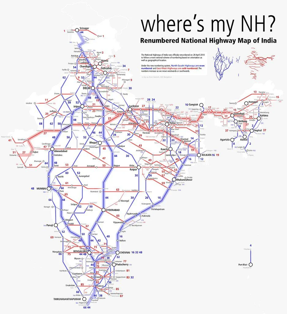
National Highway-44: the longest national highway in India, is formed by merging seven national highways, linking Srinagar in the north to Kanyakumari in the south.
National Highway-27: an east-west national highway, is the second-longest in India, connecting Porbandar to Silchar, and it falls under the maintenance of the Ministry of Road Transport and Highways (MoRTH).
National Highway-48: (formerly known as Old National Highway-8), stretching over 2,807 km, is India’s third-longest national highway, linking Delhi to Chennai and traversing seven states.
National Highway-52: traverses six Indian states, spanning a distance of 2,317 km, establishing crucial connections across the states it traverses, including its passage through the Western Ghats.
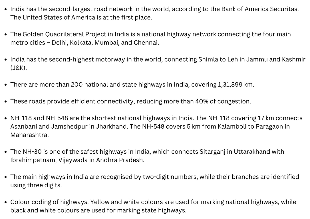
National Highway-30: previously known as National Highway-221, is the fifth-longest national highway in India, connecting Sitarganj in Uttarakhand to Ibrahimpatnam and Vijayawada in Andhra Pradesh.
National Highway-6: formerly designated as NH-40, 44, 154, and 54, links the northeastern states of Assam, Meghalaya, and Mizoram.
National Highway-53: forming a part of the AH-46 network, connects Gujarat and Odisha, officially designated as running from Kolkata to Surat.
National Highway-16: a segment of the Golden Quadrilateral Project, runs along the eastern coast of India near the Bay of Bengal, passing through West Bengal, Odisha, Andhra Pradesh, and Tamil Nadu.
National Highway-66: previously known as NH-17, stretches along the southwestern coast of India, traversing Maharashtra, Goa, Karnataka, Kerala, and Tamil Nadu, featuring diverse landscapes of hills, forests, rivers, and streams.
National Highway-19: a significant portion of the historic Grand Trunk Road, links Agra in Uttar Pradesh to Kolkata in West Bengal, also forming a part of AH-1 of the Asian Highway Network.
Biggest highways in India: Key facts
Development of national highways in India
Road connectivity in India has been enhanced through the development of highways. They have been around for a long time and are essential in the economic, political, and cultural spheres. Significant highway advancement in India occurred while under British colonial rule. In 1972, the Indian government tasked the Jayakar Committee with raising funds for road and highway development. Furthermore, the Indian Road Congress (IRC) and the Nagpur Plan were established along with other organizations.
The NHAI was established in 1988 by an act of Parliament under the Ministry of Road Transport and Highways to oversee the development, maintenance, and management of National Highways projects.
Aquire Acres.com Viewpoint
The development and upkeep of national highways in India is the responsibility of the Ministry of Road Transport and Highways. The NHAI in India is responsible for overseeing various highway projects throughout the country. These highway initiatives are designed to enhance connectivity among different areas, leading to increased economic activities and developments in the real estate sector.
Also Read: Yamuna Expressway Authority floats scheme for hotels near Noida airport: All you need to know

_1784528630.webp)
_1784272311.webp)


Ans 1. NH 44 covers the North-South Corridor of NHDP and it is officially listed as running over 4,112 km (2,555 mi) from Srinagar to Kanyakumari. It is the longest national highway in India.
Ans 2. Total Number Of Highways Known as the second largest road network of the world, there are over 200 National Highways in the country. With a cumulative length of about 101,011km, the Indian Road Network, has a total length of 1,31,899 km, when considered with the state highways.
Ans 3. (i) National Highways constitute only about 1.7% of the total road network but carry about 40% of the total volume of road traffic. These highways are well connected. (ii) These highways connect states. (iii) These highways are meant for inter-state transport and movement of defence material in strategic areas.
Ans 4. 01. National Highway 44. National Highway 44 is the longest National Highway in India, spanning over 3,700 km. It connects Srinagar in Jammu and Kashmir to Kanyakumari in Tamil Nadu, passing through several major cities such as Delhi, Agra, Jaipur, Mumbai, Hyderabad, and Bengaluru.
Ans 5. Uttar Pradesh has the longest network of National Highways in India. Only three other states of Rajasthan, Maharashtra & Gujarat have a route length of more than 5000 Kms.